
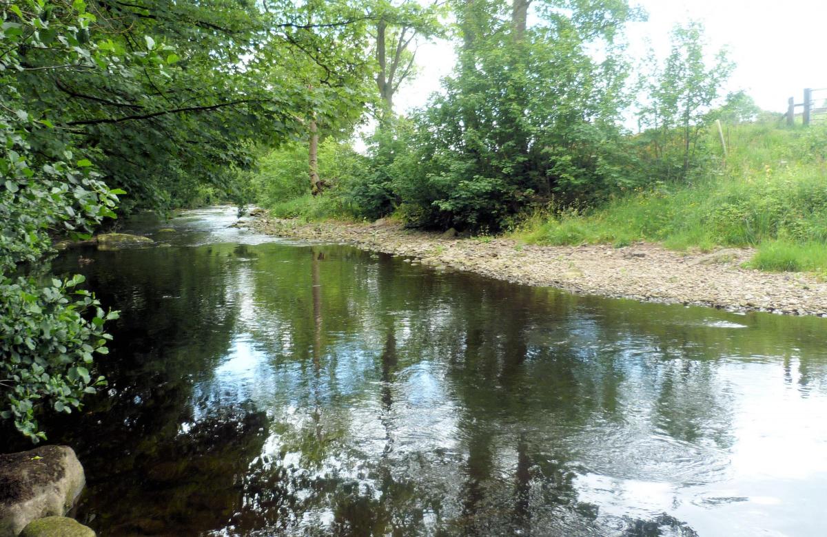
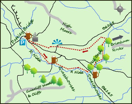
SOUTH of Pateley Bridge, the River Nidd is a more tranquil beast. Gone are the wild moors, replaced by a more tranquil scene, a scene of historical villages, farmlands and the unique rock formations of Brimham Rocks.
There are some quaint shops and buildings in the attractive small town of Pateley Bridge. The most noteworthy is the sweet shop, advertised as the oldest in England. Start the walk by heading to the road bridge over the river and heading south on its northern bank. The footpath clings closely to the river bank. Soon after leaving the village arrive at ‘Pillars Past’, a depiction of three, tall man-sized stone figures representing agriculture, mining and the monks of yore. From here the path sticks to the river before taking a diversion through the settlement of Glasshouses after a mile. A dam just off the river (water used for the old mill) provides a beautiful base for wild fowl, I spotted moorhens and geese when I passed. The mill is rumoured to have supplied rope for the ill-fated Titanic.
Return to the river and follow it for another mile to Low Laithe and then take the lane heading inland to Smelthouses (the second signed footpath in a small distance. The monks of Fountains Abbey provided the origins of the name when they built a smelt mill to process the iron ore mined from the fell side above Pateley Bridge. At the west end of the village the well signposted Nidderdale Way enters some attractive woodland beside a small lake/pond. The Nidderdale Way is one of the most attractive and varied long distance walks, it is only 55 miles long but visits both the wild moors north of Pateley Bridge and the quieter lands in the lower dale.
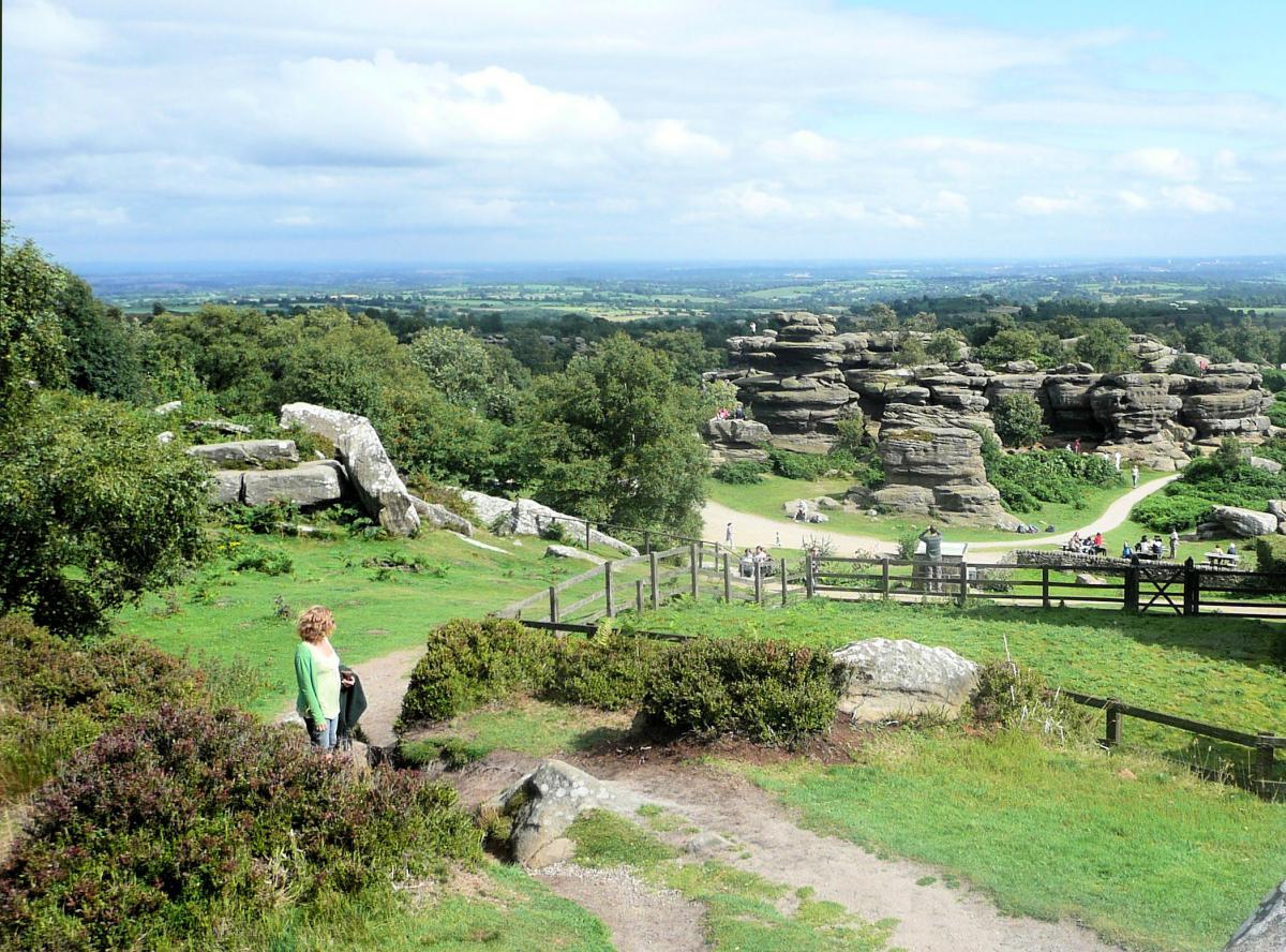
Soon after crossing the small river of Fell Beck the path comes to a lane. The Nidderdale Way turns left back towards Pateley Bridge, while a right turn leads steeply up hill to Brimham Rocks. If you have time and have never visited before then Brimham Rocks are definitely worth a visit. The rocks are an astonishing site, sculptured over millions of years of ice, water and heat. They have formed great boulders of gritstone rock, all of different shapes and many climbable. They provide an exciting visit for young and old alike. Return from the rocks, downhill and through woodland to Fell Beck.
There are a number of paths at Fell Beck, but I chose the one heading directly up its western bank (leaving the Nidderdale Way temporarily), initially on a lane that crosses the beck at a footbridge and climbs up alongside a wall, and past the quarry at White Houses. The views south down the Lower Nidderdale valley are excellent. Back on the Niddedale Way the path is well marked and obvious on the ground as it continues over a number of dry stone walls. After three-quarters of a mile there is a short section of road (turn left for 200 metres) but the Way then carries on above Ripley Bank. Here there is a good viewing platform near the Knott, commissioned for Queen Victoria’s Golden Jubilee in 1887. Before dropping in to Pateley Bridge turn right and follow the lane to the remains of St Mary’s Church, beautifully kept even though it is little more than a shell.
Fact box:
Distance: Roughly 7.5 miles (excluding Brimham Rocks).
Height to Climb: 280m (920 feet).
Start: SE 157654. There is a car park just to the south side of the bridge.
Difficulty: Medium: The walking is generally straightforward and at a low level, the paths are good but it may take longer than you anticipate.
Refreshments: There is plenty of places to eat and drink in Pateley Bridge, including the sweet shop.
Be Prepared: The route description and sketch map only provide a guide to the walk. You must take out and be able to read a map (O/S Explorer 298) and in cloudy/misty conditions a compass (essential on this walk). You must also wear the correct clothing and footwear for the outdoors. Whilst every effort is made to provide accurate information, walkers head out at their own risk. Please observe the Countryside Code and park sensibly.
Jonathan Smith runs Where2walk, a walking company based in the Yorkshire Dales:
• He has published 2 books on walks in the Dales, ‘The Yorkshire 3 Peaks’ and ‘The Dales 30’ mountains. Available direct from the Where2walk website.
• Book a Navigation Training day (Beginners or Intermediates). All dates and information on the website. Next available date June 5th.
• Leisurely guided walks up Pen-y-Ghent, Ingleborough and Whernside. Next dates are in July
Jonathan’s popular website, Where2walk.co.uk also features 100’s of walks across Yorkshire and beyond, from easy strolls to harder climbs.


Comments: Our rules
We want our comments to be a lively and valuable part of our community - a place where readers can debate and engage with the most important local issues. The ability to comment on our stories is a privilege, not a right, however, and that privilege may be withdrawn if it is abused or misused.
Please report any comments that break our rules.
Read the rules here