
Jonathan Smith runs Where2walk, a walking company in the Yorkshire Dales. Jonathan has written his own book, the Dales 30 which details the highest mountains in the Dales. He also runs one-day navigation courses for beginners and intermediates. Join his Learn a Skill, Climb a Hill weekends in the Dales. To find out more details on any of the above visit his website, where2walk.co.uk
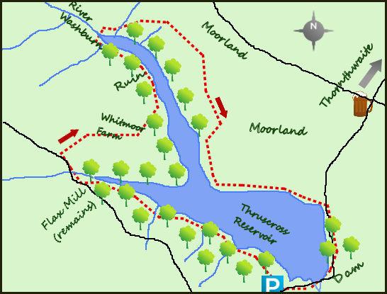
THRUSCROSS Reservoir lies north of the A59 and to the west of the lower reaches of Nidderdale. The four-and-a-half mile walk around the reservoir visits the remains of a drowned village, some wild moorland and some lovely lakeside walking full of wildlife (particularly at this time of the year).
Near the dam on the southern end of Thruscross lies the free Yorkshire Water car park and the best if not only place to start the walk. I head clockwise around the reservoir. Leave the car park via the main entrance, cross the road and enter the woodland via a gate. The path leads down to the water edge. Thruscross is the fourth of the Washburn Valley reservoirs, only completed in 1966. Turn left and follow the good path which clings close to the water for nearly one mile. The views across the water are good but the woods restrict wider viewing at this stage.
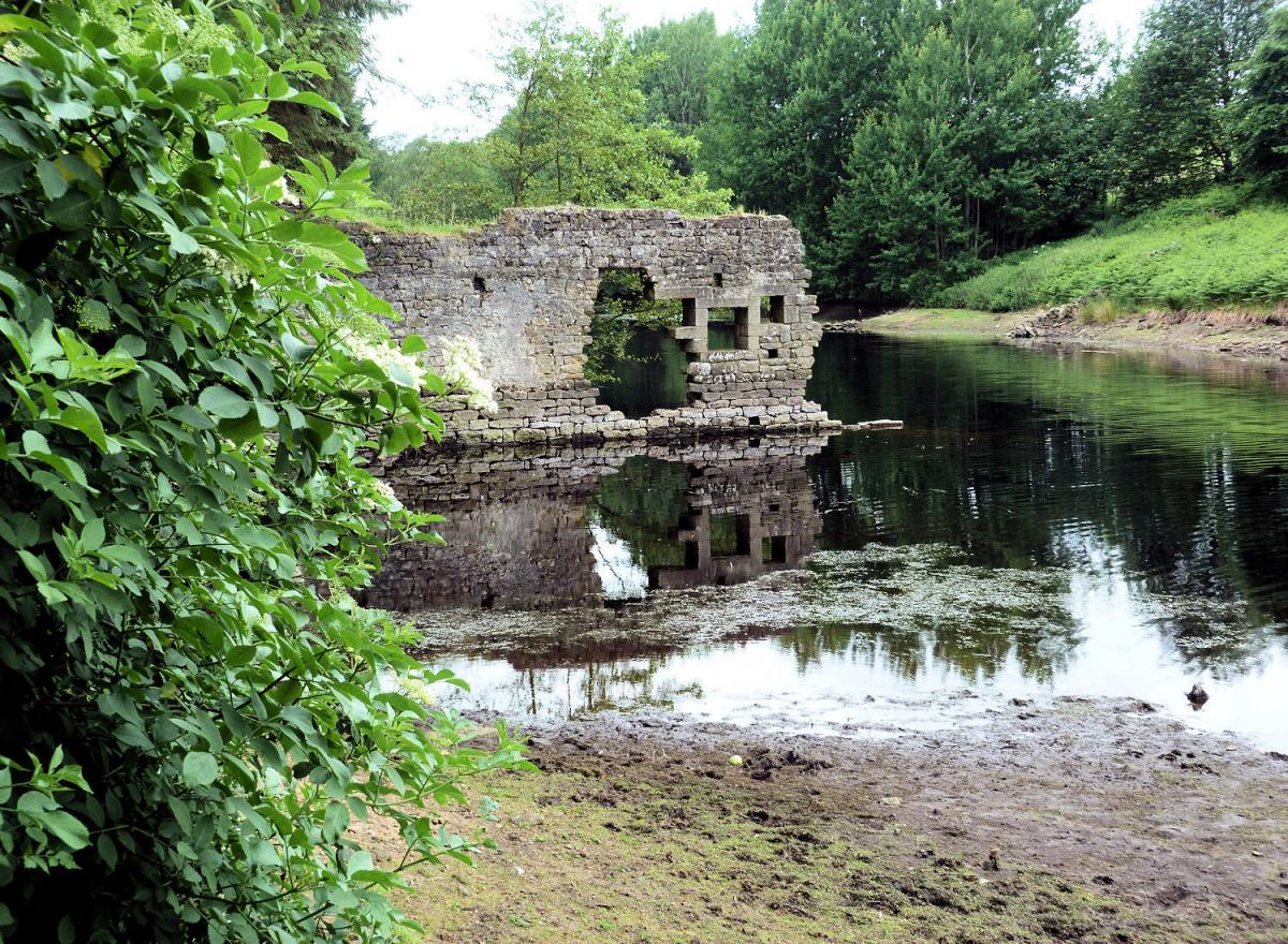
The construction of the reservoir resulted in the drowning of the small village of West End. Around this north west corner of the reservoir are a number of reminders of the village’s past, particularly after a period of dryer weather. The remains of the flax mill are particularly noticeable along the first of the two north- western arms but other remains of the village can also be seen. An interesting and slightly macabre side view is that the bodies from the churchyard at West End were exhumed and re-buried out of harm’s way at Greenhow Hill Road. A stile on the first north west arm leads on to a minor road that crosses Capelshaw Beck.
The road climbs from the road bridge but before the steeper section head right along a lane, past some farm buildings following the public right of way towards Whitmoor Farm. From the farm the road turns left at the edge of the forestry - enter some wilder moorland walking for three quarters of a mile. Where the woods end the path drops sharply to a footbridge crossing the River Washburn. This is a lovely spot, on the cusp of some very wild and untamed land to the north. Please note on the O/S maps the best route, preferred by Yorkshire Water, is orange of colour. Once over the river follow this path up to some obvious sandstone rocks before it bends south east and south. The views are the most open of the walk, particularly at this time of the year before the bracken starts to overrun the path.
As the path bends south it drops towards the reservoir, over a ladder stile before arriving water side. Turn left and follow the obvious path, flagged in places alongside the water till it enters some woodland. Turning due south follow the path for a further 300 metres before it climbs to join the road. Follow the road as it turns right and crosses the dam wall with great views both north over the reservoir and south over a large open landscape. After the dam turn left in to the car park.
Fact File:
Distance: Roughly 4.5 miles
Height to Climb: 170m (560 feet).
Start: SE 154574. There is a free Yorkshire Water car park.
Difficulty: Medium: Not a straightforward reservoir walk with some climbs and rougher walking but all the better for it.
Refreshments: Bring your own! There is nothing nearby.
Be Prepared:
The route description and sketch map only provide a guide to the walk. You must take out and be able to read a map (O/S Explorer 297 & 298) and in cloudy/misty conditions a compass (essential on this walk). You must also wear the correct clothing and footwear for the outdoors.


Comments: Our rules
We want our comments to be a lively and valuable part of our community - a place where readers can debate and engage with the most important local issues. The ability to comment on our stories is a privilege, not a right, however, and that privilege may be withdrawn if it is abused or misused.
Please report any comments that break our rules.
Read the rules hereLast Updated:
Report this comment Cancel