
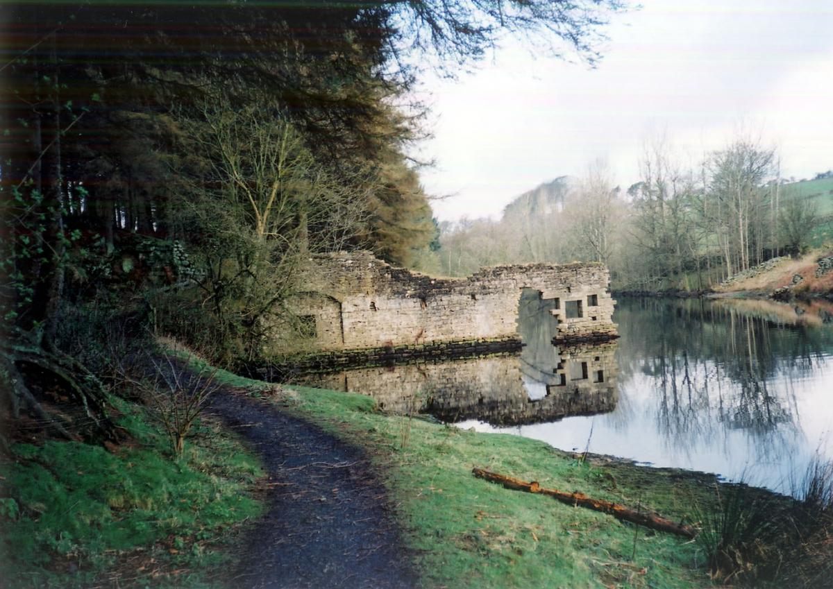
It’s strange to walk beside the calm surface of a reservoir, rippled only by swimming ducks, geese and the occasional rising trout, and remind yourself that beneath those 1,725 million gallons of cloud-reflecting water are the remains of a church, cottages, a school, country lanes and garden walls.
The village of West End isn’t a mythical place. It existed until the start of the 1960s, when it was evacuated, its buildings largely demolished and the trees around it felled.
That work was done prior to the completion, in 1966, of the dam which created Thruscross Reservoir, the fourth and highest of Yorkshire Water’s Washburn Valley reservoirs (Fewston, Swinsty and Lindley Wood are the others, in descending order).
West End re-emerges from time to time – not rising from the water like some spectre, but when there’s a drought and the water level drops dramatically. That happened in the summers of 1989 and 1990.
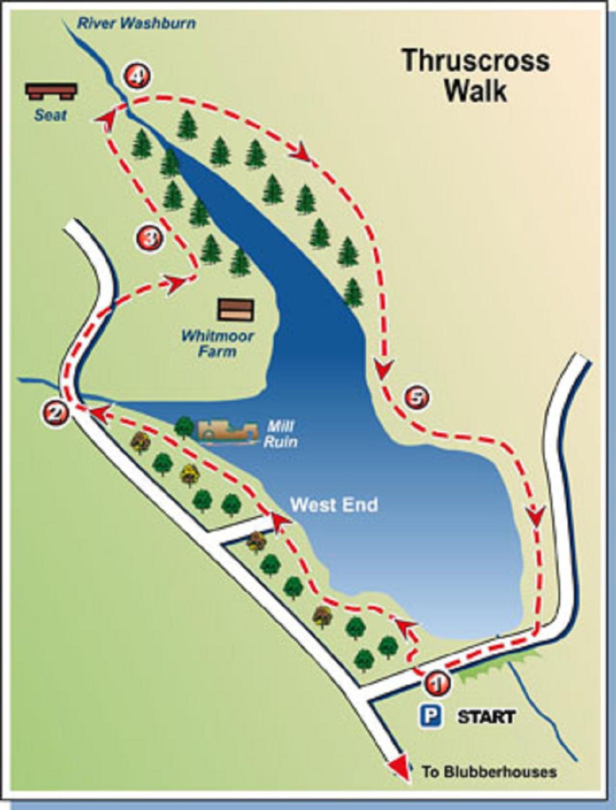
Route:
On this walk you set off from the Yorkshire Water car park off Reservoir Road (a well-made one with display boards, picnic tables and benches, though no toilets) and head off through the woods on a well-made path along the western shore of the reservoir.
The woodland has been thinned to let more light through, many of the felled trees being left to lie and rot to provide food and cover for wildlife of various types. You might spot chaffinches darting between the trees, as well as tiny warblers or even herons if you’re lucky.
Cross the truncated road that once led to West End, its crumbling tarmac disappearing into the water, and continue alongside the western spur of the reservoir to the point where Capelshaw Beck joins it. There you meet the road.
If you take a sharp right at the far side of the bridge you rejoin the reservoir via a path through the trees. But this walk follows Yorkshire Water’s recommended, permissive route.
Go up the hill on the road. At the top, turn into the access road of Whitmoor Farm and within 250 yards turn off it to follow fields paths which lead to the northernmost tip of Thruscross. The views are fantastic, the moors and fells to the north and the reservoir chain stretching down the valley in the opposite direction.
Continue along the top of the tree-line to arrive at a rustic seat, placed there in the names of Victor and Annie Verity who both died in 1984.
After soaking in the sights, head down the steep, stepped hillside to a sturdy if not particularly attractive footbridge.
At the junction head up the steep steps towards Rondell’s Allotment (not into the woodland to rejoin the reservoir). At the top stroll along the wide, grassy track, following a line of well-spaced waymark posts, to eventually swing round towards the south and return to the reservoir. This stretch of footpath isn’t as well-made as on the far shore.
With the dam carrying Reservoir Road in the distance, head along the paved stretch back to the car park.
Step-by-step:
1 From main entrance to Yorkshire Water car park, cross Reservoir Road and go through stile into wood. Follow good, made path to water’s edge and head north, detouring away from reservoir shore briefly a couple of times to cross footbridges, close to where old road disappears into the water, below, and eventually walk alongside western fork of reservoir, past ruin of old mill, to arrive at road.
2 Turn right in road, cross bridge and walk up hill beyond. Pass private drive to house on right and at top of hill go right into access track for Whitmoor Farm. When this road meets a gate with footpath signpost, go left and walk on with wall on right to stile in corner. Climb this stile and go left over immediately adjoining one.
3 Continue with wall on right to a gate with stile next to it. Don’t go over this, but instead turn left following direction indicated by signpost, half-left across field on clear track, soon walking parallel with fence and tree line on right to arrive at ladder stile. Over this, walk ahead to seat then go down steep steps to footbridge.
4 Across bridge, walk up steps ahead towards rocky outcrops then continue on to open moor Roundell’s Allotment. Follow posts across this to gate and stile in facing fence. Walk up to next post with rising ground beyond. Don’t be tempted to turn right here and head for another post down hill. Instead continue in same line over brow of hill. Keep following posts as path swings south and eventually leads to stile and path descending to reservoir side.
5 At water’s edge, turn left and follow clear path round shore to arrive at road. Follow road across embankment and back to start.
FACTFILE
Start: Thruscross car park in Reservoir Road.
Time for 4½-mile walk: two hours-plus.
Going: moderate, with a couple of steep uphill pulls.
Map: OS Explorer 27, Lower Wharfedale & Washburn Valley.
Toilets and refreshments: none along route.
Getting there: from Otley, take the Blubberhouses road to junction with A59. Cross straight over into narrow road signed to West End. Follow this looking for Reservoir Road on right. Turn into car park (free).


Comments: Our rules
We want our comments to be a lively and valuable part of our community - a place where readers can debate and engage with the most important local issues. The ability to comment on our stories is a privilege, not a right, however, and that privilege may be withdrawn if it is abused or misused.
Please report any comments that break our rules.
Read the rules hereComments are closed on this article